During discussions of the impending closure of the Valero refinery, a possible decline in cancer incidence in Benicia is promoted as a good outcome worth the economic fallout.
Not mentioned, though, is the fact that cancer has already been on the decline in Benicia for the past decade. A possible faster decline is desirable, but a decline during continuous operation of the refinery is food for thought.
Discussions on this topic sometime refer to the chart in the following screenshot, which shows the incidence of lung cancer in Solano county.
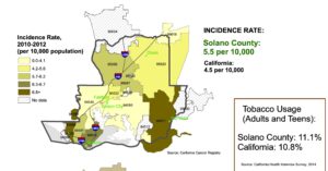
It shows the lung cancer incidence rate to be 5.5 per 10,000 residents, the rate for the State of California to be 4.5 per 10,000, and the rate for ZIP Code 94510 somewhere between 6.3 and 6.7 per 10,000.
The chart was published in 2017 by the Solano County Public Health Epidemiology Unit. It’s based on data from the years 2010 to 2012. It’s a snapshot, and there’s been no update since then. Here’s a link to the chart: https://solanocounty.com/civicax/filebank/blobdload.aspx?BlobID=26168.
However, it is easy to locate more recent data. One source is the National Cancer Institute, whose latest report shows the 2017-2021 incidence of lung cancer in California counties.
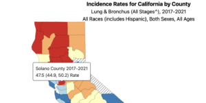
In Solano county, the rate is 47.5 per 100,000 (4.75 per 10,000 just to keep things straight), which is almost 14% lower than the figure shown in the chart, above. (Source: https://statecancerprofiles.cancer.gov/incidencerates/index.php?stateFIPS=06&areatype=county&cancer=047&race=00&sex=0&age=001&stage=999&type=incd&sortVariableName=rate&sortOrder=default&output=0#results).
What about Benicia? The California Cancer Registry reports cancer incidence on a sub-county, or zone, level on their California Health Map website. For the same 2017-2021 range, the lung cancer incidence rate for a zone that includes Benicia west of Second Street and Glen Cove was 4.35 per 10,000.
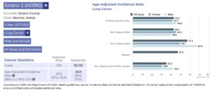
For the zone that includes the rest of Benicia and part of Green Valley, the rate was 3.97.

(Source: https://www.californiahealthmaps.org/?areatype=ctazone&address=38.09523%2C-122.10300&sex=Both&site=Lung&race=&year=05yr&overlays=labels%2Ccounties%2Ccities%2Cstreets&choropleth=AAIR). Note: the 4.35 rate is lower than the county-wide rate of 4.75 per 10,000 residents.
The California Health Map website also shows data for a ten-year range going back to 2012. During that time, in Benicia, the lung cancer rates were 4.5 and 4.35 for the two zones mentioned above. From the data, it can be shown that over the last decade lung cancer incidence in Benicia has fallen slightly west of Second Street (about 4%), and by about 9% east of Second.
Could it be that falling cancer rates don’t fit the popular narrative?